Alexander Graves
Ledbetter
30°07'21"N 96°48'17"W
 Amos Alexander and his son, also named Amos, were murdered by Indians in 1835 on the Goucher Trace near its junction with the Wilbarger Trace. The scene of the atrocity is a few miles south of present Ledbetter.
In 1935, E. H. Alexander of Llano, grandson of Amos Alexander, related the story of his grandfather's death. Amos Alexander came to Texas in 1833 and established himself on a farm in Colorado County. In 1834 the family moved to Bastrop where Amos opened a general mercantile business and a hotel. It was customary for Mr. Alexander to freight his own goods in ox wagons from Columbia-on-the-Brazos and other points to his store in Bastrop. In the summer of 1835 Alexander was returning from Columbia with two wagons of merchandise to replenish his stock. With him were his brother; his son, a lad of fifteen; a man by the name of Blackie, and Blackie's son. Alexander and probably his brother were driving the lead wagon with young Amos riding a horse at the "point." The second wagon, containing the Blackies was some distance behind. With wild yells, a group of Indians suddenly opened fire toward the three at the point. Alexander was killed and young Amos was shot through the body. He turned and raced his horse back toward the second wagon, screaming "Indians! Indians!" When he arrived at the rear wagon, Blackie's son got up behind him to hold him on the hors and the two then headed for the fort which was located at present La Grange. After riding for a distance of about a mild, the wounded youngster begged the Blackie youth to lay him down and let him die Blackie took him from the horse, laid him under a tree, crossed his hands over his breast and covered him with leaves and moss to hide his location from the Indians. Blackie continued on to the fort.
Back at the scene of the attack, Alexander's brother and the elder Blackie fought off the Indians with muzzle-loading-rifles and cap-and-ball pistols as they retreated into the brush afoot. They then made their way down Wilbarger Trace and proceeded to the fortified residence on the Colorado opposite the Bluff.
Colonel John H. Moore and all the able bodied men present saddled up and proceeded immediately to the scene of the murders. Young Amos was found dead under his mantle of leaves and the party buried him where he lay. They then located Alexander's body and buried him near a post oak tree about fifty yards north of a small branch.
The party then trekked northwest to the mountains in search of the Indians but failed to find them. They returned to La Grange.
Riders were sent out to Bastrop and the settlements on the Colorado below the fort calling on the settlers to avenge the deaths of the Alexanders. A group of sixty-two volunteers, including William Rabb, Robert M. Coleman, and John and Joseph Berry, quickly assembled and Colonel John H. Moore again to command. The party traced a group of Indians to Little River, fifteen miles above the falls of the Brazos River. There they located and captured a group of seven Indians, but they could find no trace of Alexander's goods. The men voted to execute the Indians, which was done, and they then returned to the Colorado.
Through the years the small branch on which the killings occurred was referred to as the branch "on which Alexander was killed." Finally the term was shortened to the name Alexander's Branch.
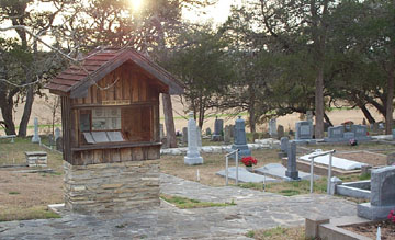
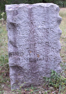
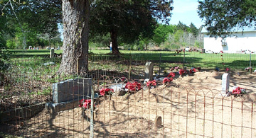
Lyman Alexander was a baby when his father was killed. He learned the story just as soon as he reached the age of reason and passed on the tale to his son, E. H., expressing his desire that the graves not be forgotten. According in 1935, the centennial year of the incident, E. H. had a granite stone engraved and put in position about 50 yards from Alexander Branch on the north bank at the site of the murders (30 degrees 07'21"N 96 degrees 48'17"W).
This stone is a large gray, granite block, roughly chipped. It is about 14" thick X 20" wide X 3' high and faces toward the southeast. The inscription is incised deeply into the rough face and reads as follows: "Amos Alexander and Son Killed by Indians here June 1, 1835."
Information on Alexander graves from Norman Krischke. Photo courtesy of Rodney Read.
Anders Family Cemetery
O'Quinn
The Anders Family Cemetery on the Anders family farm at 3848 Knape Road is probably the most recently established cemetery in Fayette County. The only grave is that of David Anders (November 18, 1943 - December 19, 2004).
Ammannsville Catholic Cemetery
St. John the Baptist Catholic Cemetery
See webpage with list of burials, link to photos and information about the Ammannsville Catholic Cemetery.
Barfield Family Cemetery
Rabb's Prairie
On October 20, 1958 Joe Cole reported: "Leon Teinert Home. One mile south of Peach (Pietsch) Store off FM Road 158. One hundred fifty yards west of the Teinert house near a large live oak tree. Two graves of Negro children of Boots Barfield. On road from Peach (Pietsch) Store to Rabb's Prairie." [Joe Cole #030E]
Barfield family research done by Kathy Carter is available in the Fayette Heritage Archives.
Bargas-Breithaupt Cemetery
Perhaps more commonly known as the Sander Family Cemetery
Holman
Norman C. Krischke writes in A Visit to the Holman Valley, self-published in 1996: "The Sander Family Cemetery was established on land owned by John and Anna Ehler, however, George Sander was living on the farm at the time and, apparently, had an agreement to buy the land. The Henry Laturnus and Henry Breithaupt families were also living on the land. Henry Laturnus married Marty Breithaupt 5 January 1893; she was, most likely, a daughter of Henry Breithaupt. George Sander married Sophie Meyer 19 October 1893. Both Henry Laturnus and George Sander were charter members of the Richard Seydler Herman Sons Lodge No. 86. Laturnus and Sander were trustees of the German Public School at Holman. Henry Laturnus, born 22 January 1864, died 5 August 1934, is buried in the Breslau Cemetery in Lavaca County, Texas. Mary's place of burial is unknown. George Sander, 1869-1942, and Sophie, his wife, 1875-1921, are buried in the Hermann Sons section of the Shiner City Cemetery." Henry Breithaupt's obituary refers to the cemetery as the "Geo. Chandler burying ground".
The cemetery is located a half mile south of the Holman Store on land owned currently by Joe Bargas. The cemetery has a woven wire-cedar post fence and is about 400 yards south of his house and 300 yards west of FM 155. There are only two tombstones. Both have multiple names.
Stone 1:
West side: Kinder von Geo. & Sophie Sander
South side: Elise Sander, 29 Jun 1894 - 10 Aug 1894
North side: Ella Sander: 5 Jun 1895 - 19 Feb 1896
Stone 2:
West side: Frida Laturnus, 16 Sep 1894 - 18 Oct 1894
South side: Hugo Breithaupt, 15 Dec 1886 - 13 Aug 1895
East side: Henry Breithaupt, 25 Nov 1834 - 3 Jun 1896
North side: Eliesa Schwegman, 19 Apr 1899 - 14 May 1900
Barta Grave
Site of the Old Sacred Heart Catholic Cemetery
Flatonia
This now unmarked grave is located at the corner of Fair Park Road and First Street in Flatonia.
Norman Krischke wrote in 1999:
"This cemetery was first surveyed 16 May 1970. At the time the site was covered with foot-high grass and there were only a few cedar trees there. Today the cemetery is covered with cedars and other saplings.
The existing graves were moved to the new Catholic Cemetery just south of the Flatonia City Cemetery in 1933 except for one, the grave of Petr Barta. Emil Farek stated that the grave was not moved because it was filled with cobbles and it was too hard to dig up.
He also stated that the concrete stone with cone on top marked the grave of a Rosenaur who died overseas during World War I and his remains returned here for burial in the spring of 1920. His remains were subsequently moved to the new cemetery.
Fayette County Birth Record, Vol. 2, Page 28:
______ Barta, M, W, born 15 September 1916 at Flatonia to Charles E. and Rosa (Nikel) Barta. S/ Dr. A.M. Kotzebue, Flatonia, Texas
The stone was not found 23 April 1999, however, the base is still in place."
The stone had read, "Zde Upanu Odpociva, Petr Barta, Nar. 15 Zari 1916, Zem. 29 Rijna 1923".
Krischke's full report with drawings can be found in the booklet, "Graves, Graves, Graves," by Norman C. Krischke, copyrighted 1999, in the cemetery files of the Fayette Heritage Archives.
Barton's Creek Cemetery
Kirtley
See a list of burials and information about the Barton's Creek Cemetery.
Bauer Grave
Warrenton
This unmarked grave is located on private property off FM 954 near Warrenton.
Norman Krischke reported the following on 10-26-1972:
Weston Bauer of Warrenton, son of William & Gesine Bauer provides information that there is a grave at his parent's old home place east of Warrenton. In 1907 his parent's had a stillborn boy which was buried near a live oak tree in front of the house. Erwin Oetken lives at the place now. (1972)
Fayette County Birth record, Vol. 1, pg. 17-18, No. 2247:
Jan. 10, 1907
_________ Bauer, male, white, stillborn. Father: William Bauer, Ginner. Mother: Gesine Cordes. Dr. Robert H. Seymour, Warrenton, Texas
Krischke's full report can be found in the booklet, "Graves, Graves, Graves," by Norman C. Krischke, copyrighted 1999, in the cemetery files of the Fayette Heritage Archives
Becker Cemetery
Also known as Bell Cemetery, Winedale
View a photo and annotated list of burials in the Becker Cemetery.
James Bell Settlement Graveyard
Also known as Bell Cemetery, Ledbetter/Waldeck
View list of grave sites in James Bell Settlement Graveyard.
Besade Methodist Cemetery
Also known as Cedar Creek Cemetery, includes Dozhier Family Cemetery
6.2 miles north of La Grange
See information and a list of grave sites at Besade Methodist Cemetery.
Bethlehem Lutheran Church Cemetery
Round Top, Texas
30°03'47"N 96°41'58"W
In October 1865, the Bethlehem Lutheran Church Congregation acquired this site as part of the church property, although it was not recorded until much later. The cemetery must have been in use before that date as the oldest marked grave is for Maria Neuthard who died 9-11-1864. It is possible that the site was first a family cemetery and then donated to the church for its burying ground.
The congregation's "Rechnungs Buch" begins giving the list of graves sold in 1867, but apparently it also includes 1866 since Lina Bauer's grave is also listed. Johannes Graeter (1839-1866), however, is not listed in the book although he is buried on lot 110. Somewhere near the beginning of the congregation all members of the church were allowed burial in the cemetery, free of charge, but the book does not give the location--only the name of the person buried, if an adult, or only "child of (father)" if a child. Thus there are graves without names and names without grave numbers.
Above information taken from "Our God is Marching On" by Rev. Martin H. Obst, John G. Banik, and other contributors c1966. This title is available in the Texas Collection of the Fayette Heritage Archives TEX OBS. There are 397 entries in the index. There are probably not that many people buried there. All unidentified graves are listed as such as well as all names given without burial locations. [Joe Cole #60E]
The Texas Historic Landmark marker text at the adjacent church states:
BETHLEHEM LUTHERAN CHURCH
A center of Lutheran faith in Fayette County. Dedicated 10-28-66 with Rev. Adam. Neuthard as first pastor. Unique pipe organ of cedar built by Traugott Wantke. Stone construction shows German architectural style.
See photograph of Bethlehem Lutheran Cemetery directory booth.
A microfilmed copy of the Bethlehem Lutheran Church records can be viewed at the Fayette Heritage Museum & Archives.
Biegel - December Family Cemetery
 According to Joe Cole in 1959 : "Four miles northeast of Halsted, Texas on property owned at present by John Schuhmacher of La Grange, Texas" are seven graves. (Joe Cole #116E)
In 1973-1974 the Lower Colorado River Authority of Austin purchased land in Fayette County for the construction of the Fayette Power Project. Several cemeteries were in the boundaries of the project acreage. All the affected burials were disinterred and moved to new sites. Descendants of the deceased were contacted and signed permits were obtained to allow the work to proceed. More than 125 burial sites were involved in the relocation project. The bodies were moved to the New La Grange City Cemetery; Old La Grange City Cemetery; New La Grange Black Cemetery; Fayetteville City Cemetery, New Biegel-December Family Cemetery (on LCRA property); Nordheim Cemetery in De Witt County; and the New Spring Hill Missionary Colored Baptist Church Cemetery.
Seven graves were identified at this site. They were moved to the new Biegel-December Cemetery in the same vicinity as the original site.
Photo courtesy of LCRA
According to Norman C. Krischke's booklet, Biegel Settlement, copyrighted 1999, the following are buried in the new Biegel-December Cemetery:
Biegel, Catharina, 20 Jun 1831 - 29 Sep 1883, daughter of Jacob and Barbie (Schmid) Winnesdoerffer, married Joseph Biegel 30 Mar 1868 as his second wife
Biegel, Joseph, 19 Mar 1803 - 12 Aug 1875
Biegel, Josephine, 7 May 1871 - 4 May 1872, daughter of Joseph and Catharina Biegel
Biegel, Margarethe, 20 Jun 1801 - 29 Sep 1866, sister of Jacob Winnesdoerffer, first wife of Joseph Biegel
December, Christine, 27 Jan 1835 - 29 Jan 1910, daughter of Jacob and Barbie (Schmid) Winnisdoerffer, married John Baptiste December 10 Oct 1853
December, John Baptiste, 26 Mar 1825 - 19 Mar 1901
December, Rudolph B. Jr, 19 Oct 1888 - 27 Jul 1910, son of Rudolph and Amalie (Meyer) December
Big Bethlehem Methodist Episcopal Cemetery
Cozy Corner
29°51'10"N 96°51'21"W
 In 1855, William H. & Mary Anna Matthews sold 15 acres for $22.50 to John W.B. Allen, Wm. H, Matthews, Alonzo Reynolds, James Reynolds, Neal Robertson, & Edmund Knowles as trustees of the Methodist Episcopal Church South to use as a place of worship and for educational purposes. [Deed record Vol. K, pg. 326]
In 1875, William H. Matthews, Alonzo Reynolds, J.R. Alexander, J.A. Trousdale, W.B. Moore, & John E. Moore trustees of Bethlehem Church sold the same 15 acres for $500 to David Ferrell, George Phillips, & Philip Shaw as trustees of the African Methodist Episcopal Church for religious & educational purposes of the AME Church, less one acre which is reserved & retained as a cemetery near the Bethlehem Church building. [Deed records Vol. 87, pg. 134]
Joe Cole reported on 6-23-1958 that this cemetery is "on Hiway 155 about 7 miles out of La Grange in the center of a Negro community (called Cozy Corner in 1992). In the center of this community you will find Big Bethlehem African Methodist Episcopal Church and a cemetery that covers 16 acres of land. This cemetery and church are shown on Fayette County maps but what most people don't know is that it is a white and Negro cemetery all in one. There is no doubt that it is one of the oldest graveyards in this part of Fayette County. The white people are all buried on the west side next to the fence line. It was not a large cemetery. . . This church is the second oldest African Methodist Church in Texas; oldest being in Galveston. These Negroes are all very friendly and their ancestors date back to slavery days. There are familiar names as Hunter, Dobbins, Holman, Young, Hounath, and others." [Joe Cole #069Ea]
Norman Krischke reports on Feb. 17, 1971: "From Hiway 77 on the Bluff, take FM 155 southeast 2 miles to a paved road on the right that leads to the south southwest and the Negro Community of Cozy Corner. Three quarters of a mile southeast of Cozy Corner on a gravel road is another gravel road on the right leading toward the west and on to the Big Bethlehem A.M.E. Church. There is a sign at the road, which reads "Bethlehem A.M.E. Church".
Krischke continues: "As one faces the front of the church, he will see on his left, toward the rear of the building, two large fenced in graves. A trail leading between these 2 plots toward the southwest, goes down the bank of a small branch, across a bridge made of 3 three foot sewer pipes, and up the opposite bank to a grove of 6 cedar trees arranged in a rough square. West of the cedar trees is a group of Spanish Dagger cactus and about 20 yards further west, toward the west corner of the tract, are the white graves. Arthur Dobbins, who lives next to the entrance to the church, told Krischke he remembers 20 to 30 white graves here, maybe more. There are a few depressions in the area without markers that could be graves. Some stones nearly impossible to decipher as per report".
On October 23, 1987 Kathy Carter and Helen Muras visited this site. We found the Black cemetery but did not attempt to find the white graves because of the dense overgrowth. We also visited the Little Bethlehem Black Cemetery located at Cozy Corner. No survey was done of any of the sites at the time.
The listing is taken from the Cole & Krischke reports as well as research done by Kathy Carter in March 1999. See "FFF Matthews" file in the archives for additional information.
White Graves at Big Bethlehem A. M. E. Cemetery
Joiner, James T., 3 Jan 1854 - 5 Feb 1873, son of H. C. & J. A. Joiner
Mathews, Cathorine, 16 May 1851 - 9 Jan 1861
Mathews, Mary A., 1 Jan 1811 - 21 Apr 1864
Turner, Harrison, 15 Dec 1875 - 15 Sep 1880, son of W. T. & J. Turner
several unreadable markers
Related Link
Bethlehem African Methodist Episcopal Church—An Historic Landmark
Billimeck Graveyard
Near High Hill
This burial site is located near High Hill, Texas. It is on the north side of High Hill Road and west of Foster/Foerster Creek. There are no markers or visible outline of a cemetery.
Joe Cole reported the following: "A lost cemetery in High Hill, TX. While at High Hill on July 20, 1958, Mr. Henry Beier showed me a place in the town of High Hill that at one time 50 years ago there was a cemetery. It is back of the dance hall on across the road in a pasture. I was told by several people at High Hill that at one time there were 20 or more tombstones there but not any of them are left nor could I find anybody that knew what went with the stones. One man whose name I did not learn said that a part of the cemetery was moved to the new Catholic Cemetery but did not know what became of the rest of the monuments." [Joe Cole #107W]
According to a report on St. Mary's Catholic Cemetery at High Hill by Norman C. Krischke in 1996: "There were some early burials on the north side of the road north of the church it what was referred to as the High Hill Lost Cemetery. It has been said these graves were of the Farenthold children and the graves were moved to St. Mary's Cemetery after it was established." In a Fayette County Deed Record dated 3-10-1888 (Vol. 32, page 199) this site is referred to as Billimeck's Graveyard in a property line description.
Mrs. Elsie Billimeck Farris supplied a paper signed by 13 people who state: "that there was a cemetery located at the back of the dance hall across the road in a pasture in the town of High Hill. The cemetery was located on the southwest corner of the farm owned by DeWitt (2000) next to the High Hill Road and the Alvin Winkler farm." Mrs. Farris believes that at least one person is still buried here, possibly the unmarried brother of Franz Adamek.
Norman C. Krischke visited the site with Mrs. Farris in late 2000 and using his divining rods found the grave of a male and female adjacent to each other. The graves are 20 feet from the High Hill Road fence line and 12 feet from a pole that is 8 feet from the fence.
Mrs. Farris supplied a hand-drawn map of High Hill as she remembers it in late 1920. The cemetery is shown on maps in the archives of Clear Title Company in La Grange.
Bittner Cemetery
1.8 miles southeast of Holman off FM 155
See Bittner family history and list of burials at the Bittner Cemetery.
Black Jack Springs Cemetery
Also known as the Black Jack Cemetery; O'Quinn
View list of burials and information about the Black Jack Springs Cemetery.
Boehnke Cemetery
Muldoon
See list of burials in the Boehnke Cemetery.
Brandt Family Cemetery
Holman
See listing of burials in the Brandt Family Cemetery and a brief family history about this Historic Texas Cemeterery.
Breeding Cemetery
Willow Springs
View list of grave sites, historical markers, and more information about the Breeding Family Cemetery.
Brendle Family Cemeteries
Rutersville
The Brendle family members are buried in two separate cemeteries located about 5 miles apart in the Rutersville area.
1. Joseph & Pauline Brendle and others are buried on the Thomas Hill Farm (1993 owner). The site is about 5 miles east of La Grange on Baumbach Road about 200 yards from its intersection with Rocky Creek Road. The graves of Joseph and Pauline are enclosed by a 12 X 10-foot iron fence, which was manufactured by the Springfield Ornamental Iron Works, Springfield, Ohio, patented 1884. The graves for the children of the ___ Marquardt family are situated on the north side of the Brendle graves. There is a marker for one of the children but the inscription is illegible. Walter Helble declared in 1982 that a Marquardt infant died in 1909. There are no markers for the other two graves. Freytag & Glaiser surveyed this site in August 1982.
Joe Cole also visited this site [Joe Cole #96E] in 1959 and he states that there is a fence around Joseph & Pauline's graves and that outside the fence is one grave with a headstone but no dates and that he was told it was the grave of Rev. P. Hayne.
2. According to the Joe Cole Survey [#14E], Gustav & Bertha Brendle and others are buried on their home place that in 1959 still belonged to the Brendle family. This sight is about 7 miles NE of La Grange.
Kathy Carter and Helen Muras located this site on 1-23-1989. From La Grange take Highway 159 to Rutersville and turn left onto Sand Rock Road/Citzler Road. Follow for approximately 2 miles and the cemetery can be seen from the road on the left about 100 yards in a pasture just past the Weldon Liebscher home. Kathy & Helen did not go to the graves.
According to Norman Krischke's report of August 1968, the site is due south of the Moore Family Cemetery. It is about 20 X 24 feet and surrounded by a fence. The entire surface is covered with concrete that is cracked and some grass and bushes grow through the graves. Krischke's map indicates that painted on the concrete is "10 graves". There are two headstones with 3 names.
From research done by Kathy Carter on 2/25/1993 it was found that Joseph Brendle is the father of Gustav Brendle. Addie Brown of La Grange visited the site on 7/10/1994 and reported that Gustav & Bertha Brendle's graves are enclosed in an iron fence. The large stone is in good shape and a smaller one next to it is in 2 or 3 pieces. Mrs. Brown reports that Ernest Friemel and his wife, Ernestine, and his second wife, Theresa Schielack, who he married on 8-20-1861, is buried here. This leaves only 4 of the graves unidentified.
Brown Family Cemetery
La Grange/Rutersville
In the spring of 1959, Joe Cole reported: "Brown Family, Negro. This little cemetery is on the property of J.C. Eineigl, father-in-law of Herbert Janssen (Gardenia F. Eineigl married Herbert Theodore Janssen 5/22/1943). The Browns sold the place to Mr. Eineigl several years ago. Located 3 miles east of La Grange, north of Hiway 159. Fannie Brown, wife of S.B. Brown, died June 9, 1914, age 71 years. Three other graves, no markers." [Joe Cole #050aE]
Sam & Eliza Brown Graves
Cozy Corner
According to the Joe Cole Cemetery Survey of 1958, these graves are on Mr. Edgar Anders property, that at one time was the Dr. J. P. Brown Plantation near the Cozy Corner neighborhood. Mr. Cole spoke with Laura Dobbins of Cozy Corner who said she was born on Dr. Brown's place in 1878 and that her mother was a witness to the events that took place on April 30, 1881. Mr. Brown killed his wife and child and then killed himself. They were buried in one grave underneath a large live oak tree. Ms. Dobbins said there was a stone at the grave and that all Mr. Cole would want to know would be found on the stone. Mr. Cole tracked down Mr. Anders who took him to the site on top of a high hill in a clump of live oak trees. There was a marble stone that was broken into 3 pieces, one piece had a pretty verse on it and the other two were blank. Mr. Anders said that about 14 years previous (c.1944) some people from Dallas had come to visit the grave and shortly thereafter he found the stone broken and the piece with the names and dates missing. Mr. Anders did not know what was inscribed on the missing piece but a black man from the area who did not want his name mentioned said that it told of the murder and suicide and he thought that a relation of Mr. Brown's had carried it away. [Joe Cole #071W]
Norman Krischke did further research on this site in December 1990 and found a news article about the incident in the La Grange Journal of May 5, 1881 (available in archives). It states that Sam Brown killed himself and his wife. He cut his wife's (Eliza W. McClellan Brown) throat with a razor and then his own with the same weapon. Mrs. Brown tried to get away from him by running to her neighbors house but Mr. Brown pursued her and caught her some 100 yards from the house where he cut her throat killing her instantly, then cut his own throat and bled to death in about two hours. While he was pursuing Mrs. Brown his daughter, about 8 years old (Lily Emma), caught his coat and begged him to desist. Mr. Brown thrust the razor around and cut her hand slightly and told her that he would kill her if she did not leave him alone. The little girl witnessed the startling tragedy and her retelling of the events is heart-rending. A Negro woman on the premises ran to the neighbors to get help. An inquest was held and the two bodies were buried at Dr. J.P. Brown's on May 1, 1881. It is generally supposed that the cause of the horrible deed was the temporary insanity of Mr. Brown, as he was not considered a bad man at heart. The deceased leave behind three little children all sick with the measles.
Further research by Krischke tells us that Samuel B. Brown married Eliza W. McClellan on January 9, 1868. Sam was the son of Dr. John P. Brown and Eliza was the daughter of S. A. & Sarah Rebecca Lucas McClellan (who are both buried at Oak Hill Cemetery in Flatonia, her name listed as Sarah A. McClellan).
According to papers in the BARKLEY-BROWN-MCCLELLAN-SLOAN file in the Freytag Collection in the Fayette Heritage Archives, the children's names were: Lily Emma (the oldest and who witnessed the incident), Harry, and Sara (or Sadie). Lilly Emma & Sara/Sadie went to live with their McClellan grandparents in Flatonia where Sara/Sadie died in January 1882 (no marked grave found). Harry went to live with his grandfather, Dr. J.P. Brown. Dr. Brown died in 1884 and Harry was sent to another Brown relative near Fort Worth. Harry and Emma were not allowed to see each other after the deaths, but when Harry was 17 (c1892) he ran away to see his sister. Lily Emma Brown married George R. Smith and possibly died 4-20-1962 in Luling. Harry Brown died several years prior to 1962.
See Colorado Citizen accounts of the murder-suicide.
Brown - Hale Cemetery
Also known as Brown Cemetery and Hale Cemetery; West Point
View list of grave sites in Brown-Hale Cemetery.
Burkhardt - Banik Cemetery
Round Top
The Burkhardt Banik Cemetery is located one mile from Round Top on FM 1467 on what was the John Burkardt farm, later bought by Otto J. Banik. The graves of fourteen relatives of these two families, as well as one unmarked grave, are enclosed by a hurricane fence
Burleson-McClure Cemetery
2 miles west of Muldoon
According to the Joe Cole report of May 10, 1958 [Joe Cole #011W] this site is: Two miles west of Muldoon, Tex on Live Oak Creek on the old John Sullivan place. One of the first graveyards in this neighborhood is known as the Burleson-McClure graveyard. There are two graves of Pitmans, uncles of Henry Pitman of Muldoon."
Cole does not say if there are any tombstones here and this site has not been located by FHMA staff. Research done in August 1995 using the Freytag files on the Burleson & McClure families indicated there was a Jonathan Burleson who was married to a Rebecca McClure. Jonathan Burleson was a Cumberland Presbyterian minister. It is possible that Jonathan and Rebecca McClure Burleson are buried here and it is recorded as such.
Additional Burleson family notes are available in the Fayette Heritage Archives
Byler Cemetery
Also known as Byler Point Cemetery, near West Point
View list of grave sites at the Byler Cemetery.
Fayette County, Texas Heritage, published by Curtis Media, Inc. in 1996,
was the source of some of the cemetery information on this page.