The Cozy Corner community along FM 3233 just west of FM 155 is mostly the home of black citizens. It has never had its own post office and is not located on most maps.
Cozy Corner – The Second Freedom Colony in Fayette County
A Footprints of Fayette Article by Carolyn Heinsohn
The Cozy Corner Community, located approximately five miles south of La Grange in the area around the intersection of FM Roads 155 and 3233, is one of two Freedom Colonies in Fayette County, the other being the Armstrong Colony, located in the western part of the county.
This autonomous unincorporated community was established in the 1870s by emancipated slaves and their descendants from the Mullins Prairie, Holman and Ammannsville areas that had been occupied by large landowners prior to the Civil War. One of these landowners was Dr. John P. Brown, who had a plantation that encompassed the Mullins Prairie area. These freedmen, many of whom were sharecroppers, tenant farmers and day laborers, wanted to own land and thrive in an area that was independent of an already developed white community.
The Cozy Corner community first had two designated areas with different names because of its topography. The lower area that is contiguous with Mullins Prairie was called “The Prayer”, a dialectal form of “The Prairie”. Much of that area has been excavated for sand and gravel in more recent times. The upper wooded area was called “Post Oak”, because of the abundance of trees of that genus.
The name “Cozy Corner”, which eventually replaced the other two names, was derived from the name of a local café built by Floyd Homer in 1947. The cafe was located across the road from the Little Bethel Cemetery that is located at the “Y” of FM Road 3233 and George Rd. One of Mr. Homer’s waitresses named the café. It burned in 1952.
Prior to the improvements made to the farm-to-market road going from La Grange to Weimar, the original road curved through the community on what is now a connecting small loop called Cozy Corner Road between FM Roads 3233 and 155 that now passes to the east.
Before the establishment of this Freedom Colony, area Anglo landowners had built the Methodist Episcopal Church South with an adjacent cemetery on 15 acres of land in 1855. A slave cemetery was established on the northwest part of this property.
After the Civil War and emancipation, many of the Anglos moved elsewhere. Eventually, much of the wooded land in the upper section called Post Oak was sold in small parcels to some of the area European immigrant settlers for the wood that it could provide for building and heating, or to black sharecroppers who had saved enough money to buy a few acres.
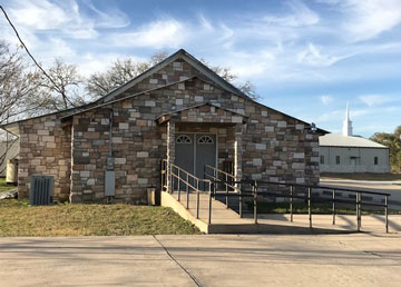
Because their faith had sustained them through their previous trials and tribulations, it was important for members of the community to establish their own church, so they purchased 14 of the 15 acres owned by the Methodist Episcopal Church South and created the Bethlehem African Methodist Episcopal Church, more commonly known as “Big Bethel”. The other remaining one acre encompasses the white cemetery. Initially, their early burials were near the white cemetery, but eventually they established a new cemetery closer to their church, because a deep ravine prevented easy access; that cemetery now surrounds the present AME Church on three sides. The church and cemetery are located off FM 3233.
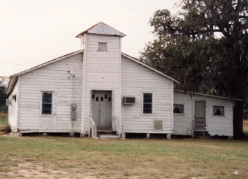
 In November1923, the trustees for the Bethlehem Baptist Church of Mullins Prairie, L.S. Scott, Jake Steveson, Wash Scott and Sammie Sanderson purchased one acre of land on the La Grange to Weimar Road from Frank J. Blaha and sons for $100.00. A church, more commonly known as Little Bethel, was built shortly thereafter. Through the years, the church building was renovated to include electricity and plumbing and eventually a new exterior surface. A much larger sanctuary was built near the old church in 2010. At that time the congregation chose a new name - New Bethel Missionary Baptist Church.
Education was considered a key to advancement, so four schools, the Lane Pool Colored School, Brown Colored School, Mullins Prairie Colored School and the Tin Top Colored School, were established for the children in the area, three as early as 1890. More details about those schools will be addressed in a future story.
There were several businesses in the area, most of which provided some type of entertainment for the residents who needed a reprieve from their daily regime of hard work, mostly in the surrounding fields. Many did seasonal work for area white farmers, including cotton picking up until the mid-to-late 1950s when cotton production declined in the area.
In addition to the Cozy Corner Café and later the Mahogany Club, there were two stores owned by Arthur Dobbins at two different locations. His first one, located on Munke Road, had kerosene, a small assortment of groceries, including Kasper’s sausage from Weimar, as well as candy, snacks and beverages. Dobbins also had a small building behind his first store where the area men played various games of chance. Zachary’s Place was a beer joint that was a popular hang-out, especially on Juneteenth when a celebration with food and musical entertainment drew large crowds. Baseball games and a small rodeo were added attractions. The building that housed Zachary’s eventually burned after being vacant for many years. Another more recent business was the Country Inn, a café owned and operated by Earline Johnson.
Fortunately, the late R.L. Homer, a native of Cozy Corner and well-known area historian, left a video account of his recollections of life in the community. Stories on the persons, places and events in the community will be extracted from that video and published in this column in the future.
Photo caption: The first Little Bethel Baptist Church in the foreground with the New Bethel Missionary Baptist Church in the background, 3240 Loehr Rd.; photo courtesy of Carolyn Heinsohn
Sources:
Fayette County Deed Records, Vol. 119; p. 319
Fayette County School Records; Fayette Heritage Museum and Archives
Homer, R.L., T.C. Filmore and Elnora East; Oral Histories
Houston, Bobbie. “Bethlehem African Methodist Episcopalian Church – An Historic Landmark”; Footprints of Fayette, August 1, 2017
Bethlehem African Methodist Episcopal Church—An Historic Landmark
A Footprints of Fayette article by Bobbie Houston
 The Bethlehem African Methodist Episcopal Church, located approximately three miles south of La Grange, is the second oldest AME church in the state of Texas. The original property was owned by William and Mary Ann Matthews, who sold 15 acres in 1855 to Reverend John W.B. Allen, William H. Matthews, Alonzo Reynolds, James Reynolds, Neal Robertson and Edmund Knowles, trustees of the Bethlehem Methodist Episcopal Church South. This early congregation was comprised of area white settlers, who also founded a cemetery for their deceased family members on the southwest side of the property, as well as another cemetery for their slaves located north of the white cemetery.
According to census records, some of these early church members moved elsewhere after the Civil War. Apparently, the church was no longer active by June 30, 1874, when the trustees at that time, namely, William H. Matthews, Alonzo Reynolds, J.R. Alexander, J.A. Trousdale, W.B. Moore and John E. Moore, sold the same 15 acres for $500 to David Ferrill, George Phillips and Philip Shaw, trustees of an African Methodist Episcopal Church. The grantees paid $214 in cash with a note for the balance plus 10% interest due by December 1, 1874. One acre of land was to be retained for the white cemetery. Interestingly, the deed was never filed until 1909 when the heirs of the grantors apparently were trying to settle their ancestors’ estates. They acknowledged the original deed as being an official document, and no further action was taken insofar as the balance due. It is not known, however, if additional payments were made prior to the filing.
The new owners retained the name “Bethlehem” for their AME Church, which is also known as Big Bethel, to differentiate it from the nearby Little Bethel Baptist Church. The church and cemetery are located at 2200 Bethlehem Church Road off FM Road 3233 in the Cozy Corner community that originally was called Post Oak. One of two Freedom Colonies in Fayette County, Post Oak was an autonomous community comprised of freed slaves in the area. Some of the early blacks in the area, who were members of the church, were the Homer, Dobbins, Holman, Conner, Hubbard, Raney, Willrich, Henderson, Scott, East, and Moore families.
The first Bethlehem AME Church was built by a Mr. Prince, who oriented the structure with the front door facing north, and the organ in the back. Oil lamps were used for lighting, wood stoves for heating, and drinking water for the congregation came from a spring-fed continuously-running stream on the east side of the property. Baptisms were also performed in the stream. According to oral tradition, the spring water was used by the entire community in the earlier days in lieu of digging wells. People also washed their clothing there and gathered wild mint that grew in the immediate area for medicinal purposes.
Prior to the installation of electricity, Frank Conner furnished Delco lights for nighttime services. When someone died, the old bell that hung in the steeple was rung to announce the death. After services, a Sunday dinner brought by the church members was served on a bench behind the church.
Initially, some of the original deceased members of the church were buried near the white cemetery located on the other side of a branch of Williams Creek. In the past, a bridge made of three 3-foot sewer pipes crossed the branch with a path that led to a grove of six cedar trees that formed a rough square. The white cemetery and black graves were located about 20 yards further west. Originally, there may have been thirty or more graves which have mostly disappeared. The bridge and path are long gone, and the graves are encroached by vegetation. When an inventory of the white cemetery was done in the 1970s, only four tombstones with legible inscriptions were still evident. Two of those were the wife and daughter of the original property owner, William Matthews. Eventually a cemetery for the black congregation was established on the east side of the creek. It now surrounds the west, north and east sides of the present church. Many of the earlier graves in this cemetery are also covered by dense overgrowth, but efforts are now underway to clear the cemetery and inventory the graves.
Eventually, the church was reoriented so that the entrance door faced the front of the property. In 1957, a small fellowship hall with a kitchen was constructed on the right side of the church, partially with lumber from the Bethesday (or Bethesda) Church. A cornerstone added to the right front corner of the church lists the names of the ministers at the time, Reverends Wash Taylor and Seth Dobbins, as well as the trustees: J. Mackey, D. Shelton, D. Willrich, B. Henderson, and S.T. Slack.
In 2000, the church was again reconstructed to include better lighting, city water, butane gas, indoor plumbing and restrooms, air conditioning, new furniture and carpeting, a pastor’s study and new attached fellowship hall.
Unfortunately, it is not possible to mention all the ministers who have served the congregation and the many faithful members who have kept the church going throughout the years. However, they all were significant in the 143-year history of this small rural African American congregation that is struggling to remain active despite all the odds against its survival.
Sources:
Bethlehem African Methodist Episcopal Cemetery history; Fayette Heritage Museum and Archives
Bethlehem African Methodist Episcopal Church 141st Anniversary History booklet; 2015
Fayette County Deed Records, Vol. K, p. 326; Vol. 87, pp. 134-136.
Homer, R.L., Tommy Filmore & Bobbie Houston; recollections and oral history
U.S. Federal Censuses for 1850, 1860, 1870, 1880
Memories of Mullins Prairie and Cozy Corner in Fayette County
By David L. Collins, Sr.
Over the last 50 years, I have traveled the roads of Fayette County in search of my ancestors who have lived and moved away from the area. During that period of time, many have returned to their family home place, and there are some who never left. A few of these African American pioneers included David Rivers, James Walter Dobbins, Elnora East, Rosie Scott, Melvin Willrich, John Faison, Louis Willrich, Clarence Phoenix, Lizzie Mae Kinder-Vaughn and Mose Vaughn and many others. Their world was in the Cozy Corner and Mullins Prairie area, where they struggled to build their lives as slaves, sharecroppers and tenant farmers.
Having an opportunity to meet some of these early pioneers and their descendants has been a blessing and a treat, especially listening to their stories and oral traditions which span over 150 years. One such person is Leo Vaughn, Jr. of Fort Worth, Texas, who was born in Cozy Corner, the son of Mose and Lizzie Mae Kinder-Vaughn. He was born in 1938 and is a walking history book. Growing up, he lived with his family, who were tenant farmers on the August Hensel place, located between Loehr Road and the Colorado River, east of FM 155. One of his best friends was the late R. L. Homer, another walking-Cozy Corner history book.
Growing up in Cozy Corner, Leo attended the Lane Pool School and being a curious person, he got to know Arthur Dobbins, who owned a café and club called the Flat, as well as area musicians like Albert Collins, who performed at the Flat, and Rev. Johnson, who was James Walter Dobbins’ mother. One person he always talks about is his mentor, Ed. Risper. He lived with Mr. Risper in 1944 for a while.
Ed Risper was born on July 4, 1878 in Fayette County, Texas on Independence Day. His mother and father were born in South Carolina and North Carolina respectively. His father was West Risper. Ed grew up during the boom time of the Cozy Corner area and on September 27, 1890, he married Matilda Conner. Some say she was a Faison, and others say she was a Cawer, but most of the people in the Cozy Corner and Mullins Prairie area knew her simply as “Matilda”.
Ed and Matilda were the proud parents of 18 children born between 1890 and 1920. In the 1910 census, Ed listed his occupation as farmer and employer; he owned his own home that was mortgage free and was able to read and write, although he only had a 2nd grade education.
 In my discussions with Leo Vaughn, Jr. who spent much of his spare time helping Mr. Risper, he indicated that Ed Risper was a great man. Risper owned a great deal of land and also owned a syrup and molasses mill and a cotton gin, according to Mr. Vaughn, although the gin ownership cannot be proven. There was an early gin adjacent to the Brown School (for whites) on what was the L.D. Brown property on Loehr Road. Perhaps Risper either owned or co-owned that gin. Through his hard work and by saving his money, he was able to buy additional land in tax sales. Mr. Vaughn also indicated that he believes that Risper donated land for a school site, which more than likely was for the Lane Pool School. In 1915, Ed Risper was one of 26 tax paying voters who signed an election petition for issuance of bonds to start a new Mullins Prairie School District. They won the election in October 1915, so the trustees of the district purchased two acres of land from L.D. Brown at the northern junction of Mullins Prairie Loop and Loehr Road for a new school for the white children of the area; it was renamed the Mullins Prairie School.
Based on the 1948 Edgar Tobin Map and Oil Well locations, Ed Risper and his descendants owned land along Lane Pool Road just west of the intersection of Loehr and Lane Pool Roads. The land that was later owned by his oldest son, Will Risper, was the site of the original location of the Lane Pool Colored School. One source states that the school was located next to Sissy Risper’s home. It is evident from his involvement and donations that Ed Risper was very interested in the education of children in the area.
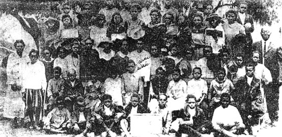
Ed Risper also owned land at the intersection of Mullins Prairie Loop and Cotton Gin Road across from the old Elias/Naiser gin near FM 155, as well as along FM 3233, south of FM 155 near the Cozy Corner community. The tract of land that Risper owned on Mullins Prairie Loop was close to a small tract of land that was donated before 1890 by Bedrich and Veronica Parma for the Mullins Prairie Colored School. When the old Brown School for white children closed, it was moved and added onto the Mullins Prairie Colored School, making it a two-room school with two teachers. Leo Vaughn sent me a picture from R.L. Homer taken in 1923 of students in front of what most probably was that school with Sissie Risper, one of the daughters of Ed Risper, labeled in the middle of the picture.
There was also another colored school in the district located on the south side of Munke Road on the other side of Williams Creek near Criswell Creek across from the old Herman Munke farm. It was a small one-room school building with wooden-shuttered windows known by some as the Tin Top School and by others as the Radhost Colored School. Perhaps Tin Top was a nickname for the school. Armstead Vaughns, born on September 6, 1908, the son of Sip and Adaline Vaughns, attended the Radhost Colored School, which indicates that it was in existence in 1914. There was also a Radhost School for white students located at two different sites, the last one on a hill on East Radhost School Road.
On a recent site visit, as I was driving west on FM 3233 near the Little Bethel Cemetery, I saw a familiar-looking gentleman mowing a large tract of land across from the Little Bethel Cemetery, so I stopped and introduced myself. It just so happened to be Melvin Willrich, whom I had met a year or two earlier. I asked him about the old Lane Pool Colored School and the Tin Top Colored School, also known as the Radhost Colored School, and he immediately pointed to a building adjacent to the west end of the Little Bethel Cemetery and said that it was the old Lane Pool School that is now a residence. He added that it was a combination of the area colored schools. I have since learned that with consolidation of rural colored schools in circa 1947, the Lane Pool School was moved to that new site, given an addition and renamed the Hostyn District Colored School. Students from the Mullins Prairie and Tin Top/Radhost Colored Schools were transferred there to join the Lane Pool School students in a two-room building.
Leo Vaughn indicated that growing up in the Cozy Corner area was a wonderful experience. He roamed all over and knew just about everyone. He does not remember when the schools were combined, but going to the Hostyn District Colored School brought back old memories of teachers, especially Willie Davis, Mamie Prince and Lucille Hearne-Hayes. He indicated that Mrs. Hearne produced some of the greatest school plays with student actors, including the Scotts, Slacks and Homers. He commented that she could have been a great producer/director like Lee Daniels, who produced the “The Butler”.
Leo also remembers some of the greatest local baseball players such as Tom L. Faison, L. B. Scott and James Johnson. He said these guys were great players and should have made it to the major league; however, they could not play with the local teams because of racial discrimination.
Mr. Vaughn also said that he was always a hustler and at six years old, he would find odd jobs wherever he could. One such job was working for a Jewish merchant named Jake Palmer, preparing chickens and eggs for shipment to Houston. He remembers two sizes of cases, a 30-dozen case and a 15-dozen case.
Mr. Vaughn often comes back to Cozy Corner and looks for the local landmarks; however, they are all gone. The Lane Pool and Tin Top/Radhost School sites are nowhere to be found. The Hostyn District Colored School building is the last-remaining vestige of the colored schools in the Mullins Prairie School District. It should have been designated as a historical landmark.
Photo caption: Students and parents at the Mullins Prairie Colored School in 1923; Sissy Risper, daughter of Ed Risper, identified with her name, is standing in the middle; photo courtesy of David L. Collins, Sr.
Sources:
Ancestry.com
Bohot, Elva, recollections
Fayette County Land and School Records
Tobin Aerial Survey/Land Records
Vaughn, Leo, Jr., former student of Lane Pool School
Willrich, Melvin, recollections
Related Links
Big Bethlehem Methodist Episcopal CemeterySam & Eliza Brown Graves
Little Bethel Community Cemetery